Geographic Information System
Actividad de Evaluación topografía
Geographic Information System / Computing
Programa de Curso Informática e Introducción a base de datos
Databases / Microsoft Excel
Norma Técnica NTG-013 - 2006 Edición de Cartografía Topográfica
Map / Cartography
Espacio Geográfico
Map / Landscape
Plan de Trabajo Cuatrimestral Del Docente en Pacareib
Reading (Process) / Arithmetic
Topografia-Que Es Un Topografo
Geographic Information System / Global Positioning System
GEOMARKETING Y DISTRIBUCIÓN COMERCIAL
Geographic Information System / Distribution (Business)
geografía en estados unidos
Geographic Information System / Geography
Trabajo de Topografía
Earthquakes / Fault (Geology)
Conclusión - El Software Toma el Mando (Manovich)
Raw Image Format / Geographic Information System
Transcad Curso Final General123
Geographic Information System / Matrix (Mathematics)
Aprende a Convertir Coordenadas Geográficas en Utm Y Utm en Geográficas
Infographics / Geographic Information System
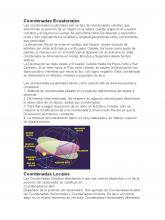
Coordenadas-Ecuatoriales
Geographic Information System / Computing
Transformación de Coordenadas.docx
Coordinate System / Geographic Information System
fotgrametria interpretacion topografica
Aerial Photography / Map
Econometría Espacial
Econometrics / Geographic Information System
Trabajo 1 topografía
Topography / Global Positioning System
Trabajo 3 topografía
Topography / Global Positioning System
11_inundaciones
Flood / Precipitation
Plataforma 3 _Sistema de radio triangulación-Camilo
Geographic Information System / Am Broadcasting
genralización en cotas
Geographic Information System / Geomatics
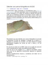
Delimitar Una Cuenca Hidrográfica en ArcGIS
Drainage Basin / Arc Gis
Métodos de Mc Harg
Remote Sensing / Geographic Information System